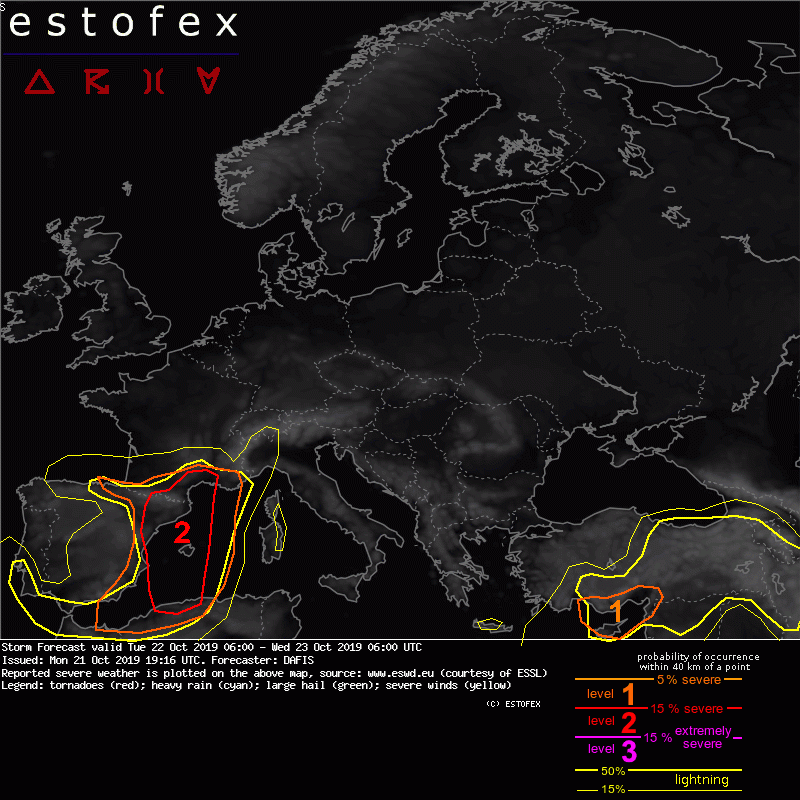

Evet hocam özellikle kıyı ege ile batı Marmarada aksiyon tavan yapacak gibi duruyor

Oraj / Dolu Takip Konusu [2025]
06:30-08:15 (GFS Sabah)
09:00-10:00 (ECMWF Sabah)
12:30-14:15 (GFS Öğlen)
18:30-20:15 (GFS Akşam)
21:00-22:00 (ECMWF Akşam)
00:30-02:15 (GFS Gece)
-
-
CAPE ve lifted index değeri bakımından yılın en güçlü sistemiyle karşı karşıyayız. Öğleden sonra tahminimi yapacağım.
Estofexin Egeye en az 2.seviyeden ve bir ihtimal 3.seviye uyarı vereceğini düşünüyorum.
-

CAPE ve lifted index değeri bakımından yılın en güçlü sistemiyle karşı karşıyayız. Öğleden sonra tahminimi yapacağım.
Estofexin Egeye en az 2.seviyeden ve bir ihtimal 3.seviye uyarı vereceğini düşünüyorum.
-10 lar var hocam cidden muazzam texasta hissetim bi an kendimi

-
Hocam tahmininiz ne zaman gelecek çok merak içindeyim doğrusu?
-
daha garanti değil kuzey batılı kalabilir ama modellerin toplam yağış verilerine aldanmamak lazım
-

daha garanti değil kuzey batılı kalabilir ama modellerin toplam yağış verilerine aldanmamak lazım
Neresi için diyorsun ??
-
Kıyı egeye gelme ihtimali çok yüksek bu sistemin ecm hiç bozmadan veriyor bize?

-
Neresi için diyorsun ??
Yağış haritana bakarsak kuzey batılı kalıyor ama yağış miktarı aldatabilir.
161764efbeb.pngbeef5f48c5b650ab9f61832.png6093448e931e700249247.png
-
Yağış haritana bakarsak kuzey batılı kalıyor ama yağış miktarı aldatabilir.
161764efbeb.pngbeef5f48c5b650ab9f61832.png6093448e931e700249247.png
İşin içine kararsızlık girdiği zaman hiç belli olmuyor geçen sistemde aliağaya 5 10 mm verdi moddeler 120 mm yağış aldı son 36 saate girdik artık model takip etmek saçma olur
-
Gecen sistemde İzmir e bu kadar yağış veriyordu sonuç ortada kararsızlık işin içine girince yağış miktarı bir hayli yükselebilir

-

Gecen sistemde İzmir e bu kadar yağış veriyordu sonuç ortada kararsızlık işin içine girince yağış miktarı bir hayli yükselebilir
bende yanıltabilir dedim.
-
ESTOFEX bugün sabah 06.00'dan yarın 06.00'a kadar uyarısı kıbrıs dikkat çekici
-
Takuma_Sato Alanya-Anamur-Silifke boyunca bir hortum veya dolu etkili olabilir mi bende bunu merak ediyorum açıkçası belki Storm Chaser yardımcı olmak isteyebilir bu merakıma
-

Takuma_Sato Alanya-Anamur-Silifke boyunca bir hortum veya dolu etkili olabilir mi bende bunu merak ediyorum açıkçası belki Storm Chaser yardımcı olmak isteyebilir bu merakıma
Sıkıntılı bir durum yok üst seviye rüzgarı yavaş. Uzun süreli ama şiddetli olmayan orajlar görülebilir bölgede.
-
Bugün 06.00 - yarın 06.00:
03fc6f6faa4b38a5e.png
-
-
b244fe8ec6ef7286a67d66.png
-
Muğla bugünü sıkıntılı geçirebilir alacağı yağışlarla.
-
83f233df36c73a.png
-
Ege Denizi genelinde, esas olarak aşırı yağmur için 1. seviye verildi.
Biscay Körfezi, batı Akdeniz, Ege Denizi:
vortisite lobunun ilerisinde, düşük seviye atlamalı hızlar iyileşir ve en son tahmin sondajları bazı düşük seviyeli MLCAPE'lere işaret eder. Fırtınalar kuzey-doğuya yayılmış durumda. Zayıf dikey rüzgar kayması nedeniyle, fırtınaların şiddetli hava üretmesi beklenmez.Yüksek CAPE nedeniyle, bazı büyük dolu ve su hortumları en çok Ege'de görülür.
İngilizce Metin
Storm Forecast
Valid: Thu 21 Nov 2019 08:00 to Fri 22 Nov 2019 06:00 UTC
Issued: Thu 21 Nov 2019 09:02
Forecaster: GATZEN
A level 1 was issued across the Aegean Sea mainly for excessive rain and to a lesser extend large hail and waterspouts.
SYNOPSIS
A large quasi-stationary trough is placed across western Europe. A strong north-westerly mid-level jet streak is directed towards the Iberian Peninsula and northern Africa. A mid-level vorticity lobe extends from the Bay of Biscay across the west Mediterranean towards the south Mediterranean. It will lift north-east during the day, affecting the Aegean Sea late in the period. A blocking high is placed across eastern Europe. At low levels, moist air masses are present across the Aegean and east Mediterranean that will overlap with steeper lapse rates late in the period. Some moisture is also present across the west Mediterranean.
DISCUSSION
Bay of Biscay, west Mediterranean, Aegean Sea
Ahead of the progressing vorticity lobe, low-level lapse rates improve, and latest forecast soundings indicate some low-level MLCAPE. Thunderstorms have formed that spread north-east. Given weak vertical wind shear, storms are not expected to produce severe weather. Due to higher CAPE, some large hail and waterspouts are most likely across the Aegean. Excessive rain is possible along the shores of western and southern France and western Corsica, Sardinia, the boot of Italy, and the Aegean.
-